

Case
Digital channel visual management remote real-time monitoring system
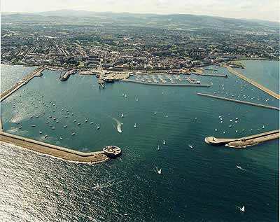
The specific application of the digital channel long distance day and night monitoring system in the field of water transportation is a technical system that integrates remote sensing, telemetry, geographic information system, broadband network, communica
Details
The specific application of the digital channel long distance day and night monitoring system in the field of water transportation is a technical system that integrates remote sensing, telemetry, geographic information system, broadband network, communication, computer vision, multimedia technology and digitalization, networking, intellectualization and visualization, and is the integration of information infrastructure and information system. It is a network image monitoring system using microwave/optical fiber communication technology, digital video processing technology, IP communication technology and other advanced communication technology. It is a supplement to the digital channel, which can be monitored 24 hours a day under various adverse climatic conditions, record the site conditions of the channel in real time, and discover the status of navigation markers, navigation conditions of ships, illegal sand mining and occupation of the channel in time. It provides good management for smooth passage, bridge safety, flood control and flood fighting, water rescue, water resources management, water conservancy facilities safety and water environment monitoring, as well as remote emergency command for emergencies occurring in the waterway, and effective linkage with environmental monitoring equipment and system. Obtain related pollution index data and form unified data backup with video, which can be used as a basis for decision-making and law enforcement for leaders of departments of Marine, maritime, waterway management, water conservancy, water transport, flood control and drought relief.
2. System features and functions
1) The system adopts a multi-spectral integrated camera, which can effectively discover and capture targets in both clear day and dark night; Advanced angular second level high precision head mechanism, improve the seismic/wind resistance performance, the image is stable and clear;
2) The system can ituitively, truly, effectively and real-time monitor the site conditions of the waterway, and timely discover the operation conditions of the waterway, traffic conditions, illegal sand mining, occupation of the waterway and other phenomena;
3) Send the video images of the channel site back to the command center in the first time, and the command center can command and dispatch the images of the electronic monitoring system to stop illegal and destructive activities in time, and link the monitoring points and targets with the GIS system;
4) The system can truly record the real situation on site before, during and after the occurrence of channel emergencies, so as to provide effective and true data for channel management;
5) As an important part of the digital waterway, visual remote monitoring has the function of integrating and linking with other waterway data monitoring, acquisition systems and waterway management systems, truly forming a waterway dynamic information management system integrating various high-tech means
6) Emergency handling: Handling of typhoon prevention in fishery, emergency rescue of regional safety accidents in fishing ports, emergency command of fishery ship safety emergencies, emergency response of storm surge and tsunami disasters, emergency response of fishery water emergencies, investigation, treatment and disposal of Marine environmental pollution damage and accidents in fishery waters, emergency response of abnormal letters and visits, etc. To provide a platform for Marine Fisheries Command Office (Emergency Command Center) to carry out relevant work.
7) Integration and combination of advanced and mature technologies such as GPS satellite positioning technology, GIS GIS technology, multi-system radio communication technology, computer network and data processing technology;
8) It can monitor and warn island invasion behaviors and accurately locate them. Through maritime satellite or high frequency digital microwave system, the images collected by the front-end video surveillance system can be transmitted to the land surveillance command center to strengthen the overall monitoring and management;
9) It can integrate the ship scheduling management AIS system to realize the visual monitoring and management of ship navigation management, water traffic management and ship comprehensive scheduling in the estuary;
Scope of application:
Digital channel visual management system
AIS ship dispatching management visual integrated monitoring and command system
Port and navigation area management and monitoring system
Bridge collision warning command system
Water traffic integrated dispatching management video surveillance system
Maritime channel operation and ship navigation management and monitoring system
Remote video monitoring system for integrated management of ocean shipping lines
Energy supply line safety management remote day and night monitoring system
Lake protection management and channel safety management video surveillance system